Nepal is a beautiful small country situated between the mighty Himalayas and the jungles of the Indian plain. It is a land of beautiful snow clad mountain peaks, yaks and yetis, monasteries, and peaceful people. Immaculate nature has beautifully designed a number of excellent trails to be walked by enthusiast mountain trekkers.
Let's discover these known or lesser known trekking routes. To embark on a trek which takes around 21 days around the entire Annapurna belt, reaching a height of 5,300 meters (17,388 feet), the circuit traverses the mountains and glaciers of the Annapurna Conservation Area. Walking through diverse terrain, from steamy jungle to high alpine, and passing through a region dominated by Tibetan Buddhist culture, brings the amazing pleasure of trekking in Nepal.
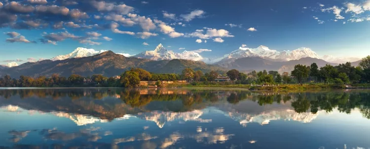
Moreover, there is Annapurna Sanctuary trek, which begins from Pokhara, leads to the base of this impressive 8,091 meter (26,545 feet) mountain. This trek takes about eight to ten days. The base camp, which is at 4,157 meters (13,638 feet), can also be reached as an extension from the Annapurna Circuit.
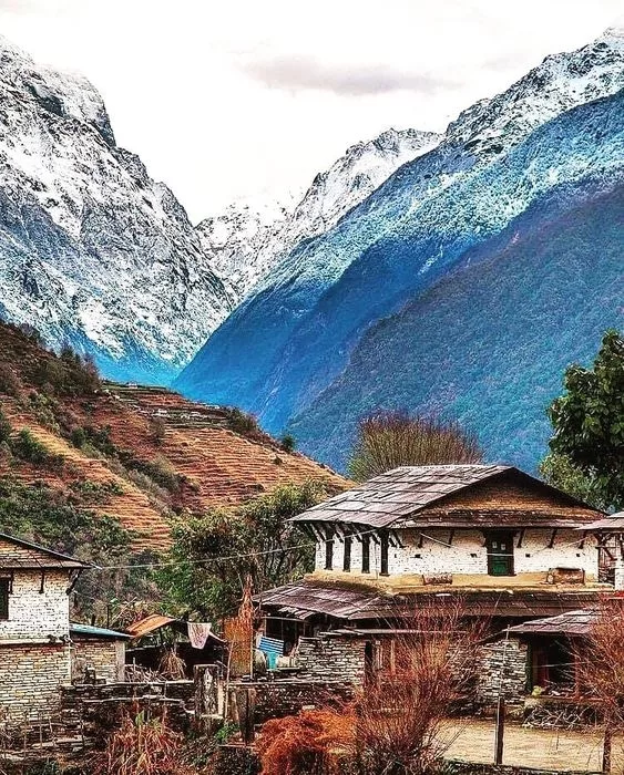
Annapurna Panorama Annapurna was the first 8000m peak to be climbed, and is the 10th highest mountain in the world. In 1950 Maurice Herzog and Louis Lachenal reached its peak. After that, until 1970 the Annapurna summit was not tried again. There were 120 expeditions to Annapurna in 1999. As of record a total of 106 climbers reached the Annapurna summit, but amongst them 54 climbers did not come back. Starting from Thamel, Kathmandu, trekkers need a guide apart from map and compass, so that they can not only learn well about the region, but also get the required help from the experienced people. Gateway to the Annapurna region is the city of Pokhara. You can reach it by plane or bus from Kathmandu. A trekking trip can be arranged from a tour agency. Most of the trekking routes have "tea houses": trekkers can stay there and meet travelers from around the world as well as get to know the local people and culture. A guide or a porter can always be hired. Annapurna Sanctuary trek (source) Let's take a look at our pocket itinerary. First you can arrive at Kathmandu at 1330m, from where we can arrange a half day sightseeing tour with a little leisure time in the end of a day. From there, you can fly to Pokhara and start your trek to Dhampus at 1990m. It includes around three hours walking. Next day you might walk for approximately 5 hours to reach Landruk at 1600 m. After that, you can commence next trek to Chomrung at 2021m, and walk approximately for six to seven hours. Next day, take a six hours walk to complete the trek to Tadapani. You can move on to next day trek to Ghandruk at 1990m, walking approximately for six hours. Near the end of this trek, you can walk for two hours to reach Nayapul, and drive for two hours to reach Pokhara again, then go back to your way to reach Kathmandu and conclude your Annapurna trek. Annapurna Sanctuary trek (source) The Trek trail between Besisahar and Bhulbhule is worth walking. You can walk the lower steps at a faster pace to spend more time on the higher steps. Some extra time can be spent at Manang and some peaks around it. See the source of the Marsyandi river in Manang as well.
Take trek trail from Pisang via Ghyaru and Ngawal, and spend the night in either of those villages to help acclimatization. From the tropical forest in Besisahar, see the snow line across the Thorung La, and then move towards the lower Mustang and Muktinath.
Himalayas In case the brief itinerary is not enough, take a look at the following detailed itinerary which is commonly found in web. Besisahar to Khudi: 7 km, 2.00 hrs Khudi to Bhulbhule: 2 km, 0.30 hrs Bhulbhule to Ngadi: 4 km, 1.15 hrs Ngadi (890 m) to Bahundanda: 4 km, 1.45 hrs Bahundanda (1310 m) to Ghermu: 5 km, 1.30 hrs Ghermu (1130 m) to Jagat: 3 km, 1.30 hrs Jagat (1300 m) to Chamche: 4 km, 1.00 hrs Chamche (1385 m) to Tal: 5 km, 2.30 hrs Tal (1700 m) to Karte: 4 km, 1.30 hrs Karte (1870 m) to Dharapani: 2 km, 1.00 hrs Dharapani (1900 m) to Bagarchap: 2 km, 1.00 hrs Bagarchap (2160 m) to Danaqyu: 2 km, 0.45 hrs Danaqyu to Thanchowk: 6 km, 2.15 hrs Thanchowk (2570 m) to Koto: 4 km, 1.00 hrs Danaqyu to Latamarang: 1.5 km, 1.00 hrs Latamarang (2400 m) to Koto: 5.5 km, 2.00 hrs Koto (2640 m) to Chame: 2 km, 0.45 hrs Chame (2710 m) to Bhratang: 7 km, 2.00 hrs Bhratang (2850 m) to Dhukur Pokhari: 6 km, 1.30 hrs Dhukur Pokhari (3240 m) to Humde: Dhukur Pokhari to Upper Pisang: 1.5 km, 1.30 hrs Upper Pisang (3310 m) to Ghyaru: 4.5 km, 1.45 hrs Ghyaru (3730 m) to Ngawal: 5 km, 1.45 hrs Ngawal (3680 m) to Humde: 2 km, 0.45 hrs Dhukur Pokhari to Lower Pisang: 6 km, 1.00 hrs Lower Pisang (3250 m) to Humde: 7 km, 2.00 hrs Humde (3330 m) to Bhraga: 6 km, 1.45 hrs Bhraga (3450 m) to Manang: 2 km, 0.30 hrs Manang (3540 m) to Yak Kharka: 9 km, 3.00 hrs Yak Kharka (4050 m) to Letdar: 1 km, 1.00 hrs Letdar (4200 m) to Thorang Phedi: 5 km, 2.30 hrs Thorang Phedi (4450 m) to High Camp: 1 km, 1.00 hrs (very steep up) High Camp (4850 m) to Thorung Pass: 5 km, 2.15 hrs Thorung Pass (5416 m) to Charabu: 6 km, 2.45 hrs Charabu (4230 m) to Muktinath: 4 km, 1.15 hrs Muktinath to Jhong: 3 km, 1.5 hrs Jhong (3540 m) to Kagbeni: 6 km, 1.45 hrs Muktinath to Jharkot: 1 km, 1 hrs Jharkot (3550 m) to Khinga: 3 km, 0.45 hrs Khinga (3355 m) to Kagbeni: 6 km, 1.45 hrs Kagbeni (2800 m) to Eklebhatti: 2 km, 1.00 hrs Eklebhatti (2740 m) to Jomsom: 7 km, 2.00 hrs (but seems longer) Jomsom (2720 m) to Marpha: 6 km, 1.30 hrs Marpha (2670 m) to Tukuche: 6 km, 1.30 hrs Tukuche (2590 m) to Kobang: 4 km, 1.00 hrs Kobang (2640 m) to Larjung: 1 km, 1.00 hrs Larjung (2550 m) to Kokhethanti: 3 km, 1.00 hrs Kokhethanti (2525 m) to Kalopani/Lete: 3 km, 1.00 hrs Kalopani/Lete (2535 m) to Ghasa: 7 km, 2.30 hrs Ghasa (2010 m) to Kopochepani: 4 km, 1.30 hrs Kopochepani (1480 m) to Rupsechhahara: 2 km, 0.45 hrs Rupsechhahara (1500 m) to Dana: 3 km, 1.00 hrs Dana (1400 m) to Tatopani: 4 km, 1.30 hrs Tatopani (1200 m) to Ghara: 5 km, 2.15 hrs Ghara (1700 m) to Sikha: 6 km, 1.00 hrs Sikha (1935 m) to Chitre: 1 km, 1.45 hrs Chitre (2350 m) to Ghorepani: 2 km, 1.15 hrs Ghorepani to Poonhill: 3km, 1.30 hrs Ghorepani (2870 m) to Ulleri: 2 km, 1.00 hrs Ulleri (2010 m) to Tikhedhunga: 2 km, 1.00 hrs Tikhedhunga (1500 m) to Birethanti: 6 km, 2.00 hrs Birethanti (1025 m) to Nayapul (1070 m): 1 km, 0.30 hrs
In Naya Pul a bus or taxi can be hired to get back to Pokhara.